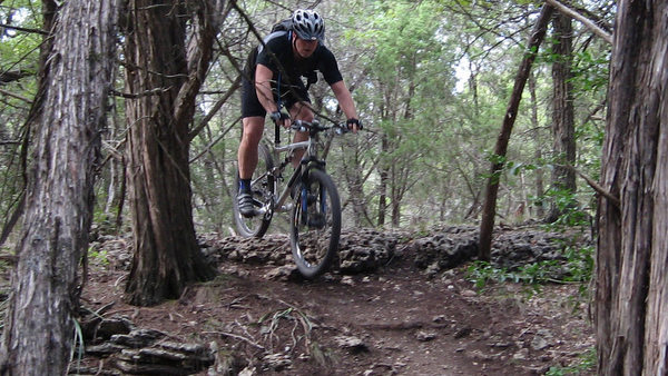
The Barton Creek Greenbelt is referred to as the "crown jewel of Austin" for a good reason - this trail represents all that is great about Austin. It's wild, accessible and right in the heart of the city. What other city has a trial like this where you can be right in the middle of everything and in only a few minutes be completely lost in nature?
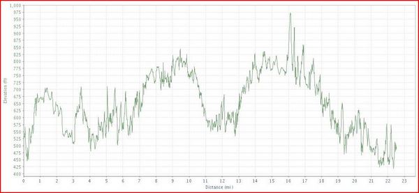
The greenbelt is a fixture for Austin mountain bikers and offers a variety of trail conditions, obstacles and challenges. The trail is based on a main trail that is about seven miles in length. In addition to the main trail there are several "back trails" that have been built over the years.
During the rainy season the trail can get very muddy and will close down. Do NOT attempt to ride if the trail is closed - that's a good way to get bikers banned from the trail. There are already enough "share the trail" conflicts with bikers and joggers/dogs that we don't need anyone else ruining it for everyone. When in doubt, you can call the hotline at 512 974 1250 to see the latest trail conditions.
Location: The greenbelt stretches from the famous Zilker Park (right off Town Lake) all the way into the western part of Travis County and the outskirts of the Austin City limits. The main trail ends near a landmark called the "Hill of Life".
Directions: There are two main places to enter the trail, the first is in Zilker Park. Take MoPac south and exit at RR 2244 (Bee Caves Road). Stay in the left lane and circle under MoPac and head east on Barton Springs Road. The park entrance is about a half mile down Barton Springs Road on your right. The second entrance is on Loop 360. Take MoPac south and follow the exit (left) for Loop 360. Take a left at the first light that you come to and pull into the non-descript office parking lot. Head all the way west to the entrance of the greenbelt. The Loop 360 entrance is less travelled by hikers so it is generally the best place to start. This does cut about 1.5 miles off of the 7 mile main trail.
Google Map of the 360 Entrance
Technical Level: Medium to high depending on whether you stay on the main trail or whether you explore the back trails.